![](/images/other/stat-length.png)
![Trail Walking La Petite-Pierre - 2021-03-06 Marche La Petite Pierre - Photo](https://media.geolcdn.com/t/1900/400/cf5f41c9-199e-470a-a027-f5d656cef4b3.jpg&format=pjpeg&maxdim=2)
2021-03-06 Marche La Petite Pierre
holtzv
User GUIDE
![Length](/images/other/stat-length.png)
Length
15.5 km
![Max alt](https://static1.geolcdn.com/siteimages/upload/files/1508320355ic_sort_altitude_max_24dp.png)
Max alt
397 m
![Uphill gradient](https://static1.geolcdn.com/siteimages/upload/files/1508320355ic_sort_den_pos_24dp.png)
Uphill gradient
488 m
![Km-Effort](/images/other/stat-length.png)
Km-Effort
22 km
![Min alt](https://static1.geolcdn.com/siteimages/upload/files/1508320355ic_sort_altitude_min_24dp.png)
Min alt
215 m
![Downhill gradient](https://static1.geolcdn.com/siteimages/upload/files/1508320355ic_sort_den_neg_24dp.png)
Downhill gradient
492 m
![Boucle](https://static1.geolcdn.com/siteimages/upload/files/16400158638029165_repeat_loop_refresh_sync_direction_icon.png)
Boucle
Yes
Creation date :
2021-03-05 18:27:33.446
Updated on :
2021-03-08 08:55:50.636
![Walking](https://static1.geolcdn.com/sitytour/trail-icons/101.png)
5h00
Difficulty : Very difficult
![Scan this QR Code to open this trail in the SityTrail application](https://capi.geolives.com/qq0zvz2zws4bq2lad0pu/sitytour/trails/2696108/qr.png?size=200)
FREE GPS app for hiking
About
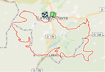
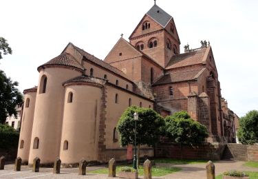
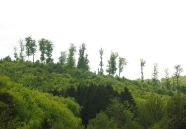
Trail Walking of 15.5 km to be discovered at Grand Est, Bas-Rhin, La Petite-Pierre. This trail is proposed by holtzv.
Description
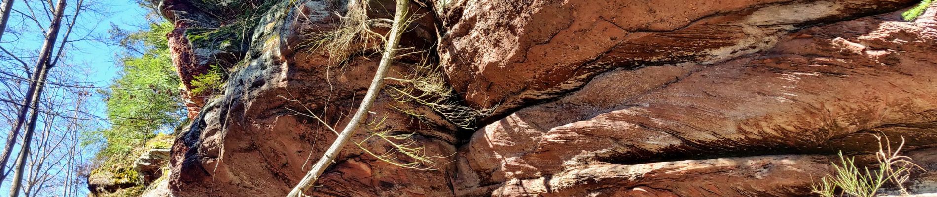
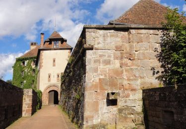
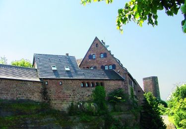
Marche autour de La Petite Pierre en passant par le Hirschfels, le Rocher des Païens, le Rocher Blanc et le château de LPP.
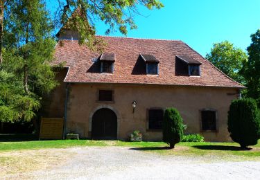
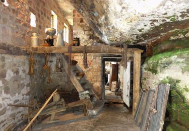
Passage par les maisons troglodytes de Graufthal en rentrant.
Positioning
Country:
France
Region :
Grand Est
Department/Province :
Bas-Rhin
Municipality :
La Petite-Pierre
Location:
Unknown
Start:(Dec)
Start:(UTM)
376664 ; 5412871 (32U) N.
Comments
Trails nearby
![Trail On foot La Petite-Pierre - Triangle vert - Photo](https://media.geolcdn.com/t/375/260/038b5fbd-ad7d-4d8f-a6b9-4f60e8eebeb8.jpeg&format=jpg&maxdim=2)
![On foot On foot](https://static1.geolcdn.com/sitytour/trail-icons/100.png)
Triangle vert
On foot
Easy
La Petite-Pierre,
Grand Est,
Bas-Rhin,
France
![](/images/other/stat-length.png)
15.1 km | 19.2 km-effort
4h 22min
![](https://static1.geolcdn.com/siteimages/upload/files/16400158638029165_repeat_loop_refresh_sync_direction_icon.png)
No
![Trail On foot La Petite-Pierre - Anneau bleu - Photo](https://media.geolcdn.com/t/375/260/35782fa9-c86a-4f9f-b3fb-0294497c25ab.jpeg&format=jpg&maxdim=2)
![On foot On foot](https://static1.geolcdn.com/sitytour/trail-icons/100.png)
Anneau bleu
On foot
Easy
La Petite-Pierre,
Grand Est,
Bas-Rhin,
France
![](/images/other/stat-length.png)
4.7 km | 6.8 km-effort
1h 33min
![](https://static1.geolcdn.com/siteimages/upload/files/16400158638029165_repeat_loop_refresh_sync_direction_icon.png)
Yes
![Trail On foot Eschbourg - Triangle rouge - Photo](https://media.geolcdn.com/t/375/260/57edd1a6-0e36-4f96-89de-82f1bb4d165c.jpeg&format=jpg&maxdim=2)
![On foot On foot](https://static1.geolcdn.com/sitytour/trail-icons/100.png)
Triangle rouge
On foot
Easy
Eschbourg,
Grand Est,
Bas-Rhin,
France
![](/images/other/stat-length.png)
6.8 km | 9.7 km-effort
2h 12min
![](https://static1.geolcdn.com/siteimages/upload/files/16400158638029165_repeat_loop_refresh_sync_direction_icon.png)
No
![Trail On foot Eschbourg - Chemin des Fontaines - Photo](https://media.geolcdn.com/t/375/260/9fa6b123-6a59-4826-87c9-3e3b8ee198f6.jpeg&format=jpg&maxdim=2)
![On foot On foot](https://static1.geolcdn.com/sitytour/trail-icons/100.png)
Chemin des Fontaines
On foot
Easy
Eschbourg,
Grand Est,
Bas-Rhin,
France
![](/images/other/stat-length.png)
6.6 km | 9.1 km-effort
2h 3min
![](https://static1.geolcdn.com/siteimages/upload/files/16400158638029165_repeat_loop_refresh_sync_direction_icon.png)
No
![Trail On foot Dossenheim-sur-Zinsel - Croix rouge - Photo](https://media.geolcdn.com/t/375/260/b7766ade-9612-4826-b6b4-3f8dbf585374.jpeg&format=jpg&maxdim=2)
![On foot On foot](https://static1.geolcdn.com/sitytour/trail-icons/100.png)
Croix rouge
On foot
Easy
Dossenheim-sur-Zinsel,
Grand Est,
Bas-Rhin,
France
![](/images/other/stat-length.png)
13.2 km | 17.1 km-effort
3h 53min
![](https://static1.geolcdn.com/siteimages/upload/files/16400158638029165_repeat_loop_refresh_sync_direction_icon.png)
No
![Trail On foot La Petite-Pierre - Triangle rouge - Photo](https://media.geolcdn.com/t/375/260/ac14cb89-5ba1-4ba9-9b9a-6e7178a855f4.jpeg&format=jpg&maxdim=2)
![On foot On foot](https://static1.geolcdn.com/sitytour/trail-icons/100.png)
Triangle rouge
On foot
Easy
La Petite-Pierre,
Grand Est,
Bas-Rhin,
France
![](/images/other/stat-length.png)
9.6 km | 13.1 km-effort
2h 59min
![](https://static1.geolcdn.com/siteimages/upload/files/16400158638029165_repeat_loop_refresh_sync_direction_icon.png)
No
![Trail On foot La Petite-Pierre - Chevalet bleu - Photo](https://media.geolcdn.com/t/375/260/b7766ade-9612-4826-b6b4-3f8dbf585374.jpeg&format=jpg&maxdim=2)
![On foot On foot](https://static1.geolcdn.com/sitytour/trail-icons/100.png)
Chevalet bleu
On foot
Easy
La Petite-Pierre,
Grand Est,
Bas-Rhin,
France
![](/images/other/stat-length.png)
9.8 km | 13.6 km-effort
3h 5min
![](https://static1.geolcdn.com/siteimages/upload/files/16400158638029165_repeat_loop_refresh_sync_direction_icon.png)
No
![Trail On foot La Petite-Pierre - Rectangle jaune barré de blanc - Photo](https://media.geolcdn.com/t/375/260/e8786cd5-b21f-4723-bb2c-f0f19066f62a.jpeg&format=jpg&maxdim=2)
![On foot On foot](https://static1.geolcdn.com/sitytour/trail-icons/100.png)
Rectangle jaune barré de blanc
On foot
Easy
La Petite-Pierre,
Grand Est,
Bas-Rhin,
France
![](/images/other/stat-length.png)
3.9 km | 5.4 km-effort
1h 13min
![](https://static1.geolcdn.com/siteimages/upload/files/16400158638029165_repeat_loop_refresh_sync_direction_icon.png)
No
![Trail On foot La Petite-Pierre - Triangle bleu - Photo](https://media.geolcdn.com/t/375/260/33b3a588-f228-473c-8257-55ea2d8fff1e.jpeg&format=jpg&maxdim=2)
![On foot On foot](https://static1.geolcdn.com/sitytour/trail-icons/100.png)
Triangle bleu
On foot
Easy
La Petite-Pierre,
Grand Est,
Bas-Rhin,
France
![](/images/other/stat-length.png)
5.8 km | 7.5 km-effort
1h 41min
![](https://static1.geolcdn.com/siteimages/upload/files/16400158638029165_repeat_loop_refresh_sync_direction_icon.png)
No